By Jeff Pope
The Manchester-By-The-Sea MBTA Zoning Task Force reduced the number of the areas under current consideration for multi-family zoning options at its meeting on Thursday, Jan. 11.
Five of the 11 areas of town that the Task Force previously identified were dropped for now, but one new area was added, and another was placed in the possible category.
The state implemented a new zoning regulation that requires each community with MBTA rail or subway service to create a “by right” zoning, allowing for an average of 15 units an acre for a certain number of acres, with at least 40 percent of those acres inside a half mile radius of the MBTA station. The remaining 60 percent of the acres can be anywhere in town.
Manchester’s required number of acres is 39, meaning 15.6 acres must be within a half mile of the station. The remaining 23.4 acres may be anywhere in the town.
The zoning rules would allow 585 units to be built over the 39 acres, but it only needs an average of 15 units per acre. So, if the new zoning allowed 18 units on some acres, some could be limited to less than 15 units.
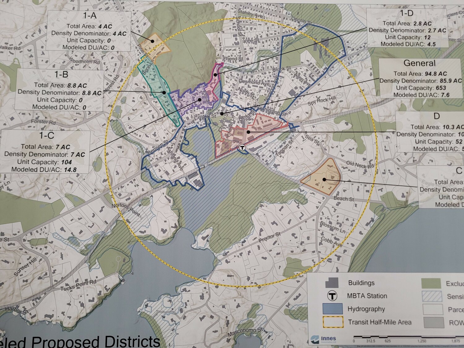
Consultant Emily Innes described each of the 11 areas previously identified, how many acres each contained, and how many units could be built in each area under the current zoning. Seven of those areas are inside (or mostly inside) the half-mile radius. The other four are outside the half-mile circle.
“What I’d like to do is winnowing down, narrow down (these areas),” said Innes. “Take things out of consideration, out of consideration.”
“Then we could have a second round of winnowing down (at the next meeting),” she added.
Following is a description of each of the areas still being considered:
- 1-A is just 4 acres and includes Newport Park and the two single-family homes just north of the senior housing. The half-mile radius runs through the middle of this section.
- 1-B is mostly on the west side of Pine Street, starting opposite Newport Park and running down to Bennett Street. It generally only includes the lots along Pine Street, with a few exceptions. It is 8.8 acres in size.
- 1-C is mostly between Pine and Elm streets from the woods south to Central Street, but not including the businesses and buildings on Central Street. It is 7 acres in size.
- 1-D is the smallest zone being considered at 2.8 acres and is east of Elm Street to Sawmill Brook and ends south of Friend Street.
- D is a section of downtown with a southern border of the railroad with lots on both sides of Beach Street, south of the intersection with Summer Street, and on both sides of Summer Street, stopping before reaching Washington Street. It is 10.3 acres in size.
- A is the only section outside the half-mile circle and consists of 75.1 acres, including the Manchester Athletic Club, the medical complex off School Street, the storage facility, and the land Cell Signaling is considering for a research and development laboratory.
- The Task Force suggested dropping the Cell Signaling land and the storage facility from this lot, leaving about 25 acres to be considered.
- Task Force member Sarah Mellish asked that another downtown section be looked into. It is generally west of Summer Street, between Manchester Memorial School and the old cemetery on Summer Street. It would include all the houses on the north side of Brook Street and a few on the south side, not including the houses on Allen Avenue, then extend from Summer Street to Norwood Avenue and include the houses on the south side of Desmond Avenue.
- Innes said she would look at this district and have numbers for it at her next meeting with the Task Force.
- The areas that the Task Force decided not to investigate any further include the following:
- The General District is 94.8 acres and ranges from Memorial School on Lincoln Street, between Summer and Norwood Avenue, down to both sides of Washington Street, Union Street, and Central Street, to the south side of Bennett Street, and everything right down the waterfront.
- B-1 (39.6 acres), B-2 (5.9 acres), and B-3 (13.2 acres), which are all near the border with Magnolia, along Summer and Raymond streets.
- C is the final area the Task Force decided to eliminate from consideration. It is a triangle of 6.6 acres between Beach Street, Old Neck Road, and Masconomo Street.
Task Force member Ann Harrison said that the B1, 2, and 3 areas did not have sewers; some were in the flood plain and were not a good choice for denser zoning.
Mellish said that the C district included only four lots, meaning that if a developer bought one or two of the lots, they could build many condos or apartments on the land if the land was included in the new zoning.
Task Force member Michael Pratt, who attended the meeting via Zoom, asked what the difference is between excluded land and sensitive land that appears on maps provided by Innes.
Innes said excluded land was land that included public buildings and schools, churches, public parks, wetlands, and water supply. Sensitive land are areas within the flood plain and can be considered in the areas for the new zoning.
Task Force member Denny Hall said he had met with three officials of Gordon College, who he said were open to the possibility of allowing some of the land, now controlled by the Gordon Foundation, in the northwest corner of town to be sold for housing. Hall said much of the land would be protected as wetlands or vernal ponds. But Hall added that the college had considered building housing for college employees on the land.
Innes said that the land would be excluded as college-owned land, but if the college sold it, the state could include it as possible land for the new zoning.
The Task Force agreed to consider that possibility.
The next Task Force meeting is scheduled for Jan. 25 at 6:30 p.m.
On Monday, Jan. 8, Task Force members Chris Olney and Susan Philbrick updated the Planning Board on the task force’s plan to hold a public forum to inform residents about their zoning.
Olney and Philbrick asked that the Planning Board participate in the forum to help residents understand the MBTA zoning rules and regulations.
They suggested the Task Force and Planning Board meet in February to plan out the forum. Still, Board Chairman Ron Mastrogiacomo said that better attendance at a March meeting was likely because of upcoming vacations.