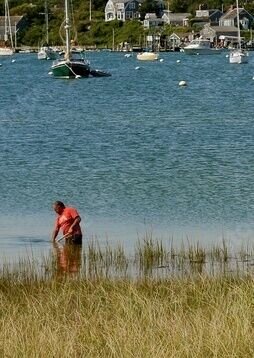
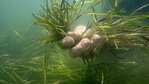
Clamming (not this clammers) can destroy portions of eelgrass beds in the Great Marsh.
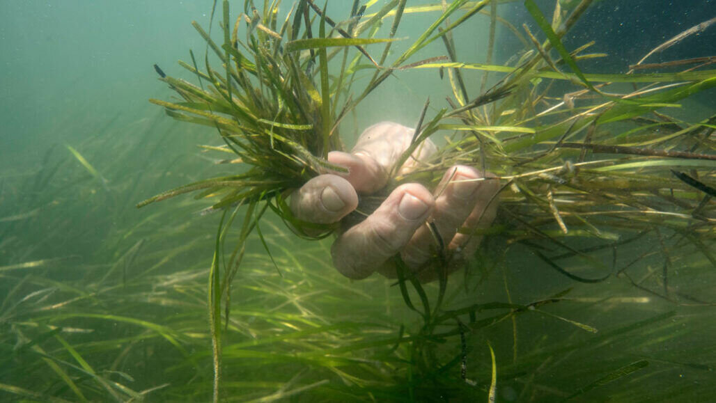
Eelgrass habitat is critical, both for providing protection for young wildlife, but also for its intense abilities as a carbon gas sequester. (Science News, Photo Courtesy)


THE 25,000 ACRES of salt marsh, barrier beaches, islands, creeks, and tidal flats in our backyard—known as the Great Marsh—looks to be a healthy, well-functioning ecosystem. We take for granted that the Great Marsh will continue as it has always been; providing us shellfish and finfish, recreational waterways, protection from storm waves, scenic vistas, and a host of other amenities.
For years, we humans have been extracting whatever we want from this estuary, while also disposing of what we don’t need or want back into it. We release wastewater, stormwater runoff, and trash, and have historically used filling and ditching for farming and pest control. Remarkably, the Great Marsh still remains relatively healthy and intact. Nevertheless, there are signs of degradation to it andits functions. This gradual destruction is being compounded by the rapid arrival of climate change and rising seas.
On the North Shore, we are very fortunate to have a wealth of people and environmental organizations who do what they can to preserve, protect, and restore the Great Marsh. Many partners have been working together to identify problems, research solutions, and implement strategies to help correct past mistakes and prepare the marsh for oncoming climate change. Federal, state, local, nonprofit, and private entities are all working together in various estuarine arenas to help save and protect this important resource. Varied collaborators such as Essex County Greenbelt Association, National Wildlife Federation, MA Division of Marine Fisheries, University of New Hampshire, Merrimack Valley Planning Commission, Ipswich River Watershed Association, the Town of Essex, Army Corps of Engineers, and many, many more are focused on restoring the Great Marsh.
A core group of organizational representatives known as the Great Marsh Partnership is leading many of the fundamental restoration activities that are underway. Some of these activities include restoring marsh hydrology (restoring the way water moves in the marsh), maintaining native marsh vegetation, dune protection, marsh bank erosion protection, and invasive species management.
The Partnership has identified marsh surface drainage concerns associated with the ubiquitous mosquito ditches from the 1930’s and ancient farming practices from the 1600’s and 1700’s. The extensive ditching and berming of the marsh both simultaneously allows too much water up on to the marsh in combination with sea level rise, while at the same time does not allow water to drain off the marsh as it should. Our team of partners is working to identify those ditches that are detrimental to natural marsh processes and are working to fix the problems.
One such approach is that mown saltmarsh grasses adjacent to the channel are rolled into the ditch. The grasses are staked down in the ditch with twine to hold the grass in place. As water from an incoming tide enters into the ditch, any sediment flowing with the tide is trapped by the grasses, helping to fill the channel from the bottom up, and eventually sealing it off. At the same time that these ditches slowly begin to fill with sediment, water is shunted to unobstructed primary ditches. With a now greater velocity of water entering and leaving these open ditches, they will continue to remain clear and even enlarge. All of this helps to keep the water flowing into and out of a given tidally-inundated area, or tide-shed, in equilibrium, and thus maintain a hydrologic balance in the marsh. Such hydrologic balance is extremely important to preserve native salt marsh vegetation and marsh stability.
Runneling is another hydrologic restoration concept being brought to fruition in the Great Marsh. This innovative technique for improving marsh function uses shallow channels that traverse only 10 to 20 feet of surface to connect to a nearby creek. The runnel allows water to partially drain from pannes (natural pools on the marsh surface) that have become unnaturally enlarged by rising seas. The pannes expand to become mega-pannes, flooding out important native vegetation along the edges. Where conditions permit, a runnel is simply constructed by compressing the marsh to form a swale-type feature. The panne then contracts to a more natural size, allowing marsh vegetation to take hold in the once flooded areas.
Thin-Layer Placement (TLP) of sediment on the marsh surface is a pioneering practice that the Great Marsh Partnership is researching for aiding the marsh surface to keep up with sea level rise. This practice uses fine materials from channel dredging operations to be dispersed in a two- to three-inch thick layer across broad sections of the marsh. The sediment on the marsh allows the marsh surface to build up while being thin enough so that the existing underlying plant assemblages are not smothered by the sediment.
Eelgrass is a plant that was once abundant in the Great Marsh, from Gloucester to Salisbury. Only about one percent of what existed 100 years ago remains in the Great Marsh today, most of that is confined to the Annisquam River. Eelgrass beds are important because they house the nurseries of many fish species. Eelgrass also stabilizes channel sediments, provides valuable habitat for shellfish, and removes carbon at a rate of 10 times that of a tropical rain forest. Over the years, hundreds of volunteers have been involved in the harvesting of eelgrass from donor meadows in the region and transplanting to create new eelgrass beds in the waters of the Great Marsh. One of the most successful eelgrass re-establishments in the state, located in the Essex River, was recently severely damaged by commercial clammers.
Another problem facing the Great Marsh is that the fragile environments of the barrier beaches of the Great Marsh are constantly under siege from climate change induced storm waves. Dune nourishment utilizing navigation dredging material is placed just offshore of the barrier beach. Through currents and wave action this sediment will gradually make its way up onto the beach. In recent years, sediment from dredging operations has been placed directly on the beach itself to build up the dunes. To help stabilize the new, vulnerable dune sediment, beach grasses are planted, often using local school groups and nearby homeowners, with great success.
The Great Marsh Partnership is monitoring eroding shorelines and researching living shorelines to protect the marsh bank from further decline from storm waves. In certain locations of the marsh, banks are stable or even accreting. But in much of the estuary, storm surge and waves are eroding the marsh bank at an alarming rate, in some cases up to 12 feet per year. Mussel beds to break wave energy and sloping of the marsh edge to allow water to ride up and over the marsh edge are two techniques the Partnership is researching to maintain marsh bank integrity.
In addition to the habitat functions of the salt marsh, it is extremely important to comprehensively maintain a prominent and extensive salt marsh ecosystem to protect our vulnerable infrastructure. The barrier beaches and salt marshes are a natural line of defense against storm surge and sea level rise. The Great Marsh Partnership and its myriad of affiliates will continue to protect and restore this valuable real estate known as the Great Marsh for all to experience.
Peter Phippen is a hydrogeologist and coastal scientist with 40 years of experience in water resources management. He is currently coordinator of the Eight Towns and the Great Marsh Committee, a division of the MassBays National Estuary Partnership and the Merrimack Valley Planning.


